HS Geography Sim Generator v3
Description
Recommended by
Nico@YouMind
Why we love this skill
This skill employs a rigorous five-step workflow to ensure high school geography simulators are accurate and interactive from scientific principles to code implementation, making it a model geography teaching aid.
This third version is iterated based on practical experience developing a three-circle circulation simulator. It refines specific cases into a general methodology applicable to generating all high school geography interactive simulators. It includes a 5-step workflow: requirements collection → architecture design → code generation and self-check → user testing → pre-delivery review. Built-in general debugging methodology, symmetry verification, boundary connection formalization, perspective visibility checks, and other practical experiences.
Related Skills
View all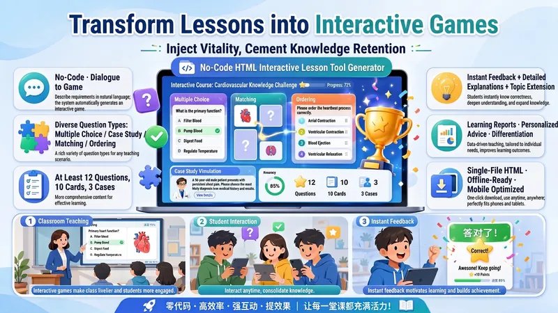
No-Code HTML Interactive Game
Guides teachers through a dialogue to clarify their needs, then generates a fully functional HTML interactive teaching tool (e.g., level-based games, knowledge quizzes, card flipping, decision simulations). Supports advanced features such as random question selection, variant question banks, stratified sampling, and knowledge map feedback. Built-in academic standard checks (e.g., statistical notation format, concept classification accuracy, self-contained explanations) ensure the generated tool is pedagogically and methodologically rigorous and reliable.
 Research
No-Code Skill Builder
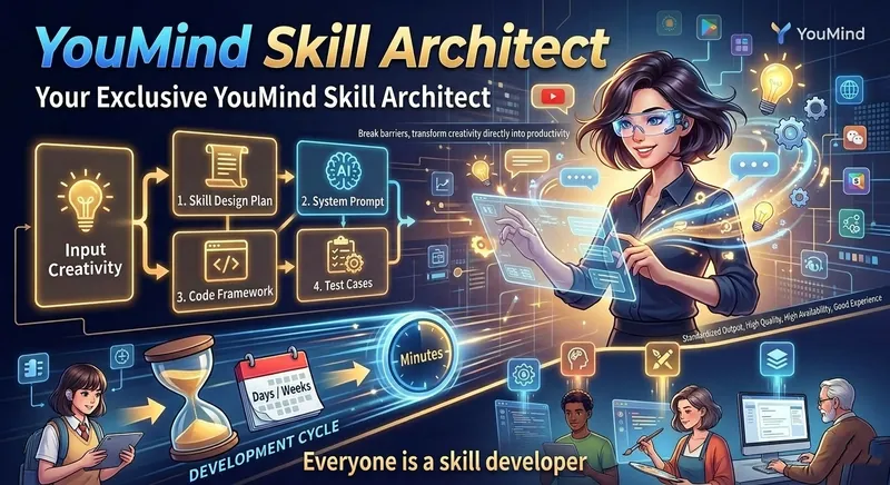
Your dedicated YouMind Skill architect. Through guided conversations, it explores your ideas and automatically produces a complete Skill design plan, System Prompt, code framework, and test cases—so anyone can turn an idea into a deployable YouMind Skill in just minutes. It reduces the Skill development cycle from “days or weeks” to “minutes,” removes technical barriers, and turns ideas directly into productivity, bringing the vision of “everyone can be a Skill developer” to life. Standardized outputs also help ensure that generated Skills deliver high quality, strong usability, and a great user experience.

Multifunctional Course Plan Builder
Generate or revise course plans for universities and vocational colleges based on curriculum standards. Choose from three task paths (targeted revision / structural overhaul / build from scratch) × six instructional method frameworks (BOPPPS, flipped classroom, project-based learning, six-step work process, case-based teaching, theory–practice integration) × two levels of detail (single plan / entire course). When no curriculum standards are available, the system automatically activates a fallback hierarchy using alternative anchors. Before each plan is finalized, it undergoes six mandatory audits: observable verbs, traceable objective anchors, compliant method stages, alignment across objectives, activities, exercises, and assessment, total instructional hours, and anti-fabrication boundaries. The plan itself is the sole primary deliverable. A mandatory self-check gate is applied before delivery, and reports or summaries may not replace the main plan. Note: If you do not need the multifunctional version, consider Course Plan Auto-Generator. This Skill focuses on automatically generating full-course plans based on the OBE approach.
HS Geography Sim Generator v3
Description
Recommended by
Nico@YouMind
Why we love this skill
This skill employs a rigorous five-step workflow to ensure high school geography simulators are accurate and interactive from scientific principles to code implementation, making it a model geography teaching aid.
This third version is iterated based on practical experience developing a three-circle circulation simulator. It refines specific cases into a general methodology applicable to generating all high school geography interactive simulators. It includes a 5-step workflow: requirements collection → architecture design → code generation and self-check → user testing → pre-delivery review. Built-in general debugging methodology, symmetry verification, boundary connection formalization, perspective visibility checks, and other practical experiences.
Related Skills
View allNo-Code HTML Interactive Game
Guides teachers through a dialogue to clarify their needs, then generates a fully functional HTML interactive teaching tool (e.g., level-based games, knowledge quizzes, card flipping, decision simulations). Supports advanced features such as random question selection, variant question banks, stratified sampling, and knowledge map feedback. Built-in academic standard checks (e.g., statistical notation format, concept classification accuracy, self-contained explanations) ensure the generated tool is pedagogically and methodologically rigorous and reliable.
ResearchNo-Code Skill Builder
Your dedicated YouMind Skill architect. Through guided conversations, it explores your ideas and automatically produces a complete Skill design plan, System Prompt, code framework, and test cases—so anyone can turn an idea into a deployable YouMind Skill in just minutes. It reduces the Skill development cycle from “days or weeks” to “minutes,” removes technical barriers, and turns ideas directly into productivity, bringing the vision of “everyone can be a Skill developer” to life. Standardized outputs also help ensure that generated Skills deliver high quality, strong usability, and a great user experience.
Multifunctional Course Plan Builder
Generate or revise course plans for universities and vocational colleges based on curriculum standards. Choose from three task paths (targeted revision / structural overhaul / build from scratch) × six instructional method frameworks (BOPPPS, flipped classroom, project-based learning, six-step work process, case-based teaching, theory–practice integration) × two levels of detail (single plan / entire course). When no curriculum standards are available, the system automatically activates a fallback hierarchy using alternative anchors. Before each plan is finalized, it undergoes six mandatory audits: observable verbs, traceable objective anchors, compliant method stages, alignment across objectives, activities, exercises, and assessment, total instructional hours, and anti-fabrication boundaries. The plan itself is the sole primary deliverable. A mandatory self-check gate is applied before delivery, and reports or summaries may not replace the main plan. Note: If you do not need the multifunctional version, consider Course Plan Auto-Generator. This Skill focuses on automatically generating full-course plans based on the OBE approach.
Find your next favorite skill
Explore more curated AI skills for research, creation, and everyday work.